Live Day and Night World Map

How to use the map

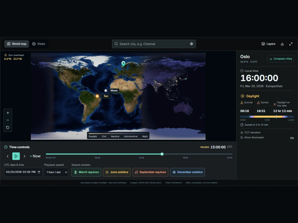
ClockTools with Oslo selected: city search, sunlight readings, the UTC timeline and date, and the Compare cities button.
  1. 01

    Choose a view

    Use the flat map to see both hemispheres at once, or rotate the globe to see the day–night boundary wrap around Earth. Use the wheel or the + and − controls to zoom; reset brings back the starting view. Fullscreen gives the map more room and keeps the essential controls available.

  2. 02

    Find a city or a point

    Search by city, select a point on the map, enter coordinates in Layers, or grant location access. The selected pin comes into view without changing your zoom. Open Compare cities next to the selected place to compare up to three locations. Select one in the list to bring it back into view.

  3. 03

    Move through time

    The clock beside the time slider shows UTC. Step one hour at a time, enter a UTC date between 1900 and 2100, or play the simulation at 15 minutes, one hour or six hours of simulated time per second. Now returns to live time. The location panel shows the corresponding local time, including seconds. Use the season buttons beside the date and playback speed to jump to an equinox or solstice.

  4. 04

    Adjust layers or share a snapshot

    Toggle twilight, city lights or the coordinate grid in Layers. Download a PNG for notes or a lesson. Copy link captures the displayed instant, selected place, time zone and map view; the recipient opens a fixed moment rather than a live clock.

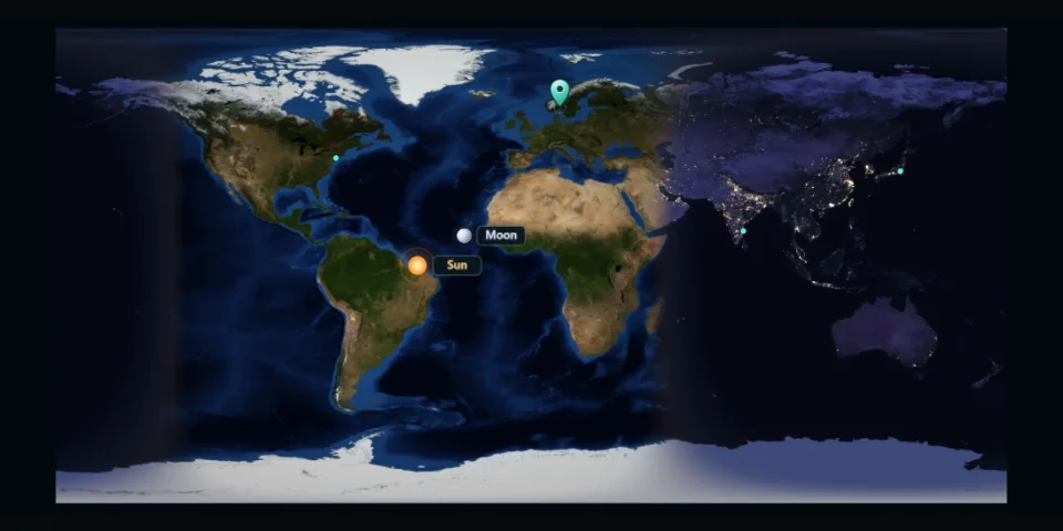
Flat map near the March equinox: the day–night boundary runs almost north to south, with Oslo marked.
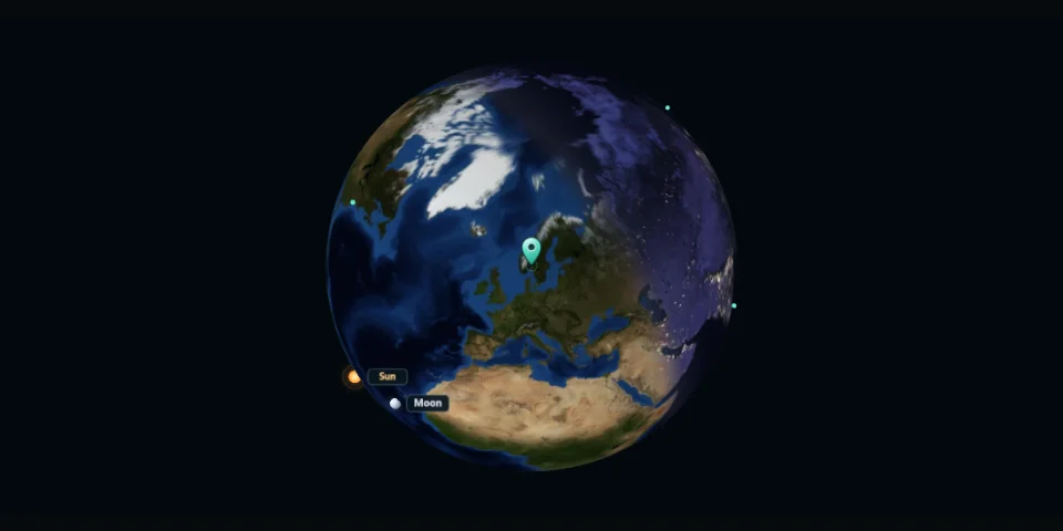
Globe view of the same instant, turned toward Oslo. The pin stays on the same place as you rotate Earth.

Equinoxes and solstices

Earth’s axis is tilted by about 23.4°. As Earth orbits the Sun, that tilt shifts direct sunlight north and south of the equator. Start with the March equinox, then select the June solstice and watch how the boundary and the daylight total change for the same city. NASA Earth Observatory

March equinox

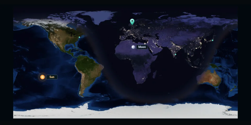
The Sun crosses the equator heading north. At the preset instant, the day–night line nearly follows the meridians. Over the following weeks, daylight generally increases in the Northern Hemisphere and decreases in the Southern Hemisphere.
June solstice

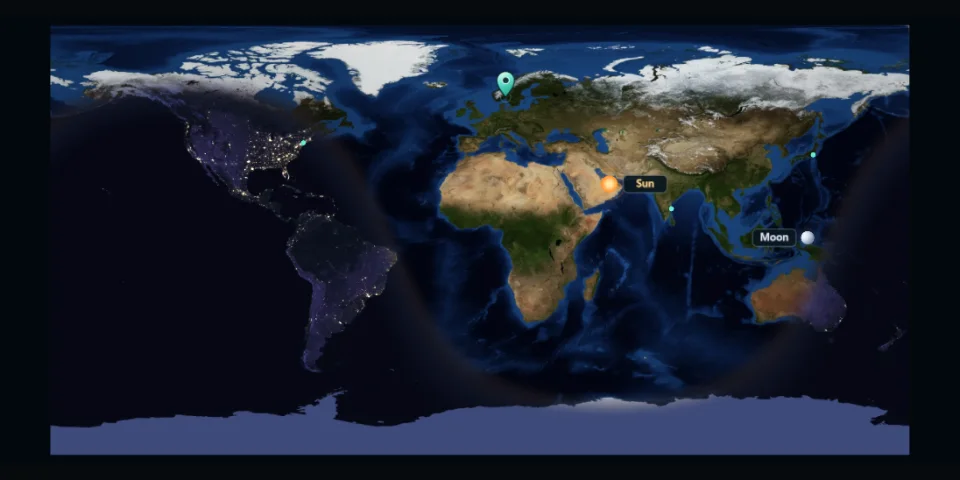
The overhead Sun reaches its northern limit near 23.4° N. Northern mid-latitudes get their longest daylight of the year and southern mid-latitudes their shortest. Try a place above the Arctic Circle to see why sunset may be absent.

September equinox

The Sun crosses the equator heading south. The global pattern looks much like March, but the trend is reversed: days generally get shorter in the north and longer in the south. Compare both presets for the same city.

December solstice

The overhead Sun reaches its southern limit near 23.4° S. The Southern Hemisphere gets longer days while the Northern Hemisphere gets shorter ones. Parts of Antarctica stay in sunlight while parts of the Arctic stay below the sunrise threshold all day.

June solstice: the Arctic faces the Sun, and the daylight boundary curves away from the North Pole.
December solstice: the daylight pattern reverses, with more sunlight around Antarctica.

Reading the map

The Sun, the Moon and the terminator

The sunlight overlay follows the calculated position of the Sun for the displayed instant, not the colors of a live camera feed. The terminator is the geometric boundary between the sunlit and unlit sides of Earth. The Sun marker identifies the overhead point; the Moon marker gives its approximate overhead position. The illuminated percentage describes the Moon’s phase, not whether you can see it from the selected city.

The three twilight bands

After sunset, the atmosphere still scatters sunlight. The conventional lower limits are 6° below the horizon for civil twilight, 12° for nautical twilight and 18° for astronomical twilight. The colors soften the transitions; they do not predict how bright a cloudy street or a mountain horizon will look. U.S. Naval Observatory

A full local day, not just the instant

The location panel shows estimated sunrise, sunset, total daylight and the next solar event when available. The colored strip covers the selected local date. A clock change can make that date 23 or 25 hours long. The day–night overlay and apparent sunrise use different horizon conventions, so the edge on the map is not an exact sunrise line.

Daylight≥ 0°
Civil twilight−6° → 0°
Nautical twilight−12° → −6°
Astronomical twilight−18° → −12°
Night< −18°

Daylight experiments

Teach the tilt of Earth

Compare Oslo and Cape Town at the June and December solstices. Read the daylight totals before explaining why the seasons reverse between hemispheres.

Open example

Plan an outdoor shoot

Choose the location and date, then slow the animation around sunset. Use the twilight band as a starting point and check weather, elevation and the local horizon separately.

Open example

Make sense of a global call

Pin three cities and set the meeting instant in UTC. Compare their local dates and see which participants will join in daylight or after dark.

Open example

Live and historical daylight

  • Where is it night right now?

    Select Now and switch to the flat map to see the whole Earth at once.

    The dark side shows where the Sun is below the horizon; use the legend to distinguish twilight from full night. To check a particular city, select it and read its current light condition in the location panel instead of judging from the background color alone. The illuminated city lights are part of a static image, not a live measure of local activity.

  • How much daylight does a city get?

    Check the Daylight value for the city’s local date, then compare it with the same city on another date.

    Try Oslo on the June and December solstices, or compare Oslo and Cape Town on the same solstice. Keep the date or season fixed while changing cities. Compare the daylight totals in the location panel, not the clock readings under Compare cities.

  • How do I look up a past or future day?

    Enter a date and time in UTC between 1900 and 2100.

    The location panel converts that instant to the selected city’s local date and time. Check the date there: an instant just after midnight UTC can still be the previous day in cities west of Greenwich. Copy the snapshot link to return to the same instant; it preserves the calculated view, not a historical photograph or weather record.

    The Sun’s position is calculated separately from the civil clock. Your browser supplies time-zone rules, which are less complete before 1970 and can change for future dates. IANA TZDB

Frequently asked questions

What year do the season presets use?

What year do the season presets use?

They use the year currently shown in UTC. Each button pauses at the calculated instant of that event, which can fall on different dates in different years or time zones. Change the UTC year before choosing the preset to compare years.

Are day and night exactly equal at an equinox?

Are day and night exactly equal at an equinox?

Not necessarily. Sunrise and sunset are based on the apparent upper edge of the Sun, and the atmosphere bends light near the horizon. Daylight is often slightly longer than 12 hours on the equinox, depending on latitude.

Why is there no sunrise or sunset listed?

Why is there no sunrise or sunset listed?

At high latitudes the Sun can remain above or below the apparent horizon for a whole local date. A missing event does not mean the tool failed. During polar night, there may still be twilight.

Is this live satellite imagery?

Is this live satellite imagery?

No. Live mode updates the calculated illumination and clocks, not the underlying Earth imagery. City lights come from a static composite and do not show current outages or weather.

How precise are the sunrise and sunset times?

How precise are the sunrise and sunset times?

Use them as sea-level estimates with an unobstructed horizon. Clouds, terrain, elevation and atmospheric refraction can change what you observe, especially where the Sun crosses the horizon at a shallow angle.

Do I have to share my location?

Do I have to share my location?

No. Search for a city, pick a point on the map or enter coordinates. If you copy a snapshot link, it includes the selected coordinates; choose a public place instead if you do not want to share your own.